floodinfo@xactus.com (844) 4EZ-CERT
Massive Advantage
We offer the widest range of features from a full-service Flood Certification vendor.
A partnership with Xactus is your competitive advantage.
[box title="products" border="hexagon" background="no" align="top" icon="fa fa-files-o fa-2x"]We offer products you won't find elsewhere. Alternative Non Guaranteed determinations at less cost but high quality. Deep-dive advanced data, unique reports, targeted marketing solutions, and Future Determinations. No artificial intelligence, just real intelligence.[/box]
[box title="value" border="hexagon" background="no" align="top" icon="fa fa-usd fa-2x"]We offer the lowest rates in the industry and plans that cater to your business model. We have single-price rates, automated and manual rates, volume-incentivized progressive discounts, pass-through or direct-billing, and any option to work around your business needs.[/box]
[box title="performance" border="hexagon" background="no" align="top" icon="fa fa-tachometer fa-2x"]Automated determinations are completed in less than 5 seconds and manual research is completed in less than an hour. We have some of the highest automation rates and lowest error rates in the industry. And our cloud-based system can scale to meet any demand.[/box]
[box title="experience" border="hexagon" background="no" align="top" icon="fa fa-university fa-2x"]Xactus is led by FEMA engineering contractors with decades of experience crafting the standards, policies, and technology in use by FEMA today. Our new perspectives may turn out to be your competitive advantage when you partner with us.[/box]
Massive Integration
Small or Large. Simple or Complex. Standard or Custom.
We conform to you, not the other way around.
Get the Right Fit
Our cloud-based modular determination system allows you to hit the ground running, or pick and choose functions that fit your business process.
Need a custom ordering web page or determination management features? We do that too. Our client-site is a custom ordering and management platform where features are designed around your needs. We can accomodate your business rules, approvals, and customer direct-billing so it fits hand-in-glove.
Web Services API
Over a dozen functions, multiple switches, and nearly 100 response fields creates endless possibilities to craft a unique solution around your business process. With a seamless Xactus integration, determination ordering is one-click easy.
Contact us for integration strategies, suggested workflows, and detailed web service documentation.
Our Loan Origination System Partners

Massive Data
These data are standard on every Guaranteed Determination for our Corporate Accounts and additionally available for any determination.
[box title='Saltwater' align='top' background='no' border='circle' icon='fa fa-tint' class="smallbox"]We'll show you the distance to the nearest saltwater source. An important pre-screening factor for private flood insurance so you have all of your options up front.[/box]
[box title='Freshwater' align='top' border='circle' background='no' icon='fa fa-tint' class="smallbox"]The distance to the nearest river, stream, lake, or pond is also an important private flood market pre-screening tool. We provide the distance and the name of water sources.[/box]
[box title='Nearest Flood Zone' align='top' border='circle' background='no' icon='fa fa-location-arrow' class="smallbox"]"In or Out" isn't the whole story. We'll tell you how close you are to a flood zone boundary for a more complete risk profile. It can make all the difference if you are close.[/box]
[box title='Future Zone' border='circle' background='no' align='top' icon='fa fa-arrow-right' class="smallbox"]If FEMA is imminently releasing a new flood map up to 6 months from today, we'll tell you the flood zone and BFE for the property based on the future FEMA map.[/box]
[box title='Elevation Certificate' border='circle' background='no' align='top' icon='fa fa-file-text-o' class="smallbox"]If we have an Elevation Certificate in our database for your flood zone determination, we'll flag it and you can download it for free.[/box]
[box title='Ground Elevation' border='circle' background='no' align='top' icon='fa fa-map-marker' class="smallbox"]Estimated from the USGS, we provide the ground elevation for the property to help facilitate risk decisions based on elevation. [/box]
[box title='Preliminary Maps' border='circle' background='no' align='top' icon='fa fa-file-text-o' class="smallbox"]Many businesses are interested in the availability of FEMA preliminary maps to help make business decisions. We'll let you know if they are available.[/box]
[box title='Previous Zone' border='circle' background='no' align='top' icon='fa fa-arrow-left' class="smallbox"]For many determinations, we provide the previous flood zone for the property. A changing zone can informs a fuller risk picture.[/box]
[box title='Datum Conversion' border='circle' background='no' align='top' icon='fa fa-random' class="smallbox"]For determinations with a Base Flood Elevation, we provide the mapped datum and the conversion for the other datum saving you time.[/box]
[box title='Newly Mapped & Pre-FIRM' border='circle' background='no' align='top' icon='fa fa-check' class="smallbox"]We check for HFIAA Newly Mapped conditions and for potential pre-FIRM conditions to help you with policy rating possibilities.[/box]
[box title='Community Losses' border='circle' background='no' align='top' icon='fa fa-usd' class="smallbox"]The community's historic flood losses are an indicator of the community's risk exposure and help make mitigation decisions beyond the flood zone.[/box]
[box title='Community Discounts' border='circle' background='no' align='top' icon='fa fa-minus' class="smallbox"]If the community participates in the FEMA Community Rating System, we'll provide the available NFIP insurance discount.[/box]
and more
Massive Reports
More Information. More Awareness. More Insight.
Want to stand out? Our massive database of natural hazard risk information can be configured to your needs and produced as a private-label report under your brand. Receive more information and risk-awareness on every property as the entire landscape of flood insurance is changing.
Risk Rating 2.0 is coming and Xactus is your partner to deliver the data and analysis you need to rate policies in the new insurance paradigm.
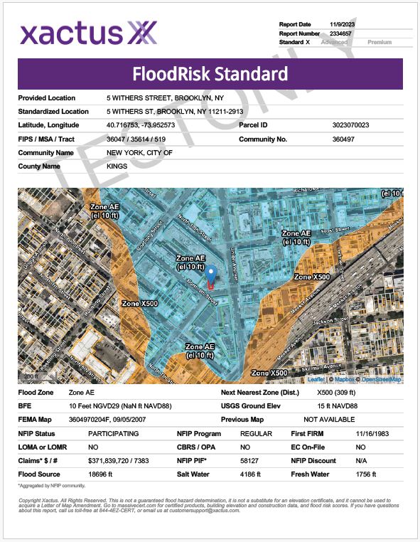
The MassiveRisk Report accompanies each determination and provides you with aerial photographs, parcel boundaries, flood zones, and the structure location. You can also find valuable information such as the available FEMA insurance discount, next nearest flood zone, distance to saltwater and freshwater, community disaster losses, and the previous flood zone. This report is very useful to communicate risk in a way that can't be done with a standard flood zone determination.
The Flood Zone Change Report shows you the effective FEMA flood zone and future FEMA flood zone. The future FEMA zone will become the effective zone in a few months, but Xactus analyzes the data before it becomes the new effective map.